Metamorf Rock

Posted by Blogger Koetai Tuesday 1 March 2011 0 comments
DefinitionMetamorfosisme process is a process that causes changes in mineral composition, texture and structure on the rocks because of heat and high pressure, as well as the active chemical solution. The end result of the process metamorfisme is metamorphic rock. So rocks are igneous rocks formed by processes metamorfisme on pre-existing rocks. Rock (which had existed previously) can be igneous, sedimentary and metamorphic.
Mineral composition    Compiler minerals metamorphic rocks can be divided into the minerals:
  • Cube-shaped minerals: quartz, feldsfar, calcite, garnet and piroksin.
  • Not a cube-shaped: mica, chlorite, amphiboles (hornblende), hematite, graphite and minerals talk.Susunan (Fabrik)
    From the appearance of three-dimensional, Fabrik can be divided into:
  • Isotropic: the composition of the grain in all directions look the same.
  • Anisotropic: the appearance of the composition of mineral grains are not the same in all directions.
Texture    Based on mineral grain size, can be differentiated into:
  • Fanaretik: grains large enough to be recognized with the naked eye.
  • Afanitik: grains are too small to be recognized with the naked eye.
Structure    Structures in metamorphic rocks known there are three:
  • Granular: if the grains interlock minerla related (inter-locking).
  • Foliasi: when the minerals form a series of flat surfaces subparalel.
  • Lineasi: if the minerals formed prismatic appearance at the juxtaposition of rocks, such as a pencil grip.
In nature, the rocks which have only very rarely lineasi structure, and most other berlineasi foliasi also formed. Foliasi may be irregular, curved or folded when deformed.

Baca Selengkapnya ....

Fundamental of Coal Petrology

Posted by Blogger Koetai 0 comments
Origin of Peat (Peat)The coal is generally derived from peat (peat) deposits in a swamp. Important factors in the formation of peat:
  • Evolution of floral development
  • Climate
  • Geography and regional structures
Evolution of Flora DevelopmentThe oldest coal-old from Michigan Central Hurorian derived from algae and fungi. While in the Lower and Upper Devonian era, mostly from coal Psilophites (spt: Taeniocrada decheniana (lower Devonian)). Most of the coal from this era had an average of a thin layer (3-4m) and have no economic value. In Carbon Up, plant start up high until it reaches an altitude of more than 30m but not seberagam now. In this era dominated by: Lepidodendron, Sigillaria, Leginopteris oldhamia, Calamitea. Age of the Upper Carboniferous period known as bituminous coal. Perm important layer of coal was found in the USSR, the dominant form of Gymnosperm cordaites. In the Mesozoic era mainly Jurassic and Lower Cretaceous, Gymnosperm (Ginkcophyta, Cycadophyta and Cornifers) is an important shaper of coal plants, especially in Siberia and Central Asia. In the old swamp and Upper Cretaceous Tertiary Angiosperm plants grow rapidly in N. America, Europe, Japan and Australia. When compared with the Carbon plant at the time, plants in the Mesozoic era, especially the Tertiary era more diverse and specific, and produces a thick peat deposits and diverse in type fasiesnya. The development and evolution will affect the diversity of flora and type of coal produced.


ClimateIn a warmer climate and wet plants grow faster and diverse. Layers of Carbon-old coal-rich Upper Cretaceous and Early Tertiary Top deposited in this climate. However, in the southern Hemisphere and Siberia there are also rich deposits of coal which diendapakan in moderate to cold climates, for example coal-post glacial inter PermoCarbon Gondwana (from Ganganopteris glossopteris) and Permian and Jurassic age coal of the Lower Angara konitnen. Coal layer is deposited in a warm and wet climate is usually lighter and thicker than that deposited in wet climates.

Tectonic and paleogeographic RequirementsLayer formation depends on the relationships and structures on the regional paleogeographic sedimentation. Formation of peat (peat) occur in the depressed area surface and surface water requires a relatively fixed throughout the year above or at least equal to the soil surface. This condition appears in many areas where a lot of flat coastal swamps associated with persisir beach. Besides the swamp also appeared on land (shore or Inland lakes). Depending on the original position of its geography, paralic coal deposit (sea coast) and limnic (Inland) is different.

Coal Paralic Swampy has few trees or no trees and formed outside the distal margin of the delta. Formation is the result of regression and transgression of sea water. Many large coastal Swampy growing under the protection of sand bars and pits that can produce thick deposits of coal.

Back samps natural levee formed behind the great river. At the back Swampy, peats (peat) is rich in mineral matter from flooding that often occurs. Peat deposits can only be preserved in the subsidence area. As a result, many coal-rich sediments associated with this area, as it often appears in the foredeep on a big mountain folds.

Sequence of thick sediment, where in it there is a thin layer of coal (<2m) with a large spread and the presence of marine intercalation is characteristic of the coal bed which was deposited in foredeeps of a large mountain folds. Cyclothem is looping between Inorganic sediment and peat with this sequence is often repeated.

In backdeeps part of a huge mountain folds, subsidence usually fewer and fewer number of layers of coal. When paralic coals deposited in foredeeps, most limnic coals deposited in a large continental basin. Limnic coals have character: formed in a continental graben, the number of layers slightly but each layer is very thick.

Baca Selengkapnya ....

Karst

Posted by Blogger Koetai 0 comments
Throughout the world karst landscapes vary from rolling hills dotted with sinkholes, as found in portions of the central United States, to jagged hills and pinnacle karst found in the tropics. The development of all karst landforms requires the presence of rock which is capable of being dissolved by surface water or ground water. The term karst describes a distinctive topography that indicates dissolution (also called chemical solution) of underlying soluble rocks by surface water or ground water. Although commonly associated with carbonate rocks (limestone and dolomite) other highly soluble rocks such as evaporates (gypsum and rock salt) can be sculpted into karst terrain. Understanding caves and karst is important because ten percent of the Earth’s surface is occupied by karst landscape and as much as a quarter of the world’s population depends upon water supplied from karst areas. Though most abundant in humid regions where carbonate rock is present, karst terrain occurs in temperate, tropical, alpine and polar environments. Karst features range in scale from microscopic (chemical precipitates) to entire drainage systems and ecosystems which cover hundreds of square miles, and broad karst plateaus. Although karst processes sculpt beautiful landscapes, karst systems are very vulnerable to ground water pollution due to the relatively rapid rate of water flow and the lack of a natural filtration system. This puts local drinking water supplies at risk of being contaminated. In the mid 1980’s, flooding of caves in the highly populated area of Bowling Green, Kentucky, caused industrial waste to leak into the vast system of underground fissures polluting the ground water in local wells. Due to urban expansion millions of dollars is spent annually in the United States to repair damage to roads, buildings and other structures which are built on unstable karst surfaces.

Baca Selengkapnya ....

Karst Topography

Posted by Blogger Koetai 0 comments
The degree of development of karst landforms varies greatly from region to region. Large drainage systems in karst areas are likely to have both fluvial (surface) and karst (underground) drainage components. As stated in the introduction, the term karst describes a distinctive topography that indicates dissolution of underlying rocks by surface water or ground water. Water falls as rain or snow and soaks into the soil. 
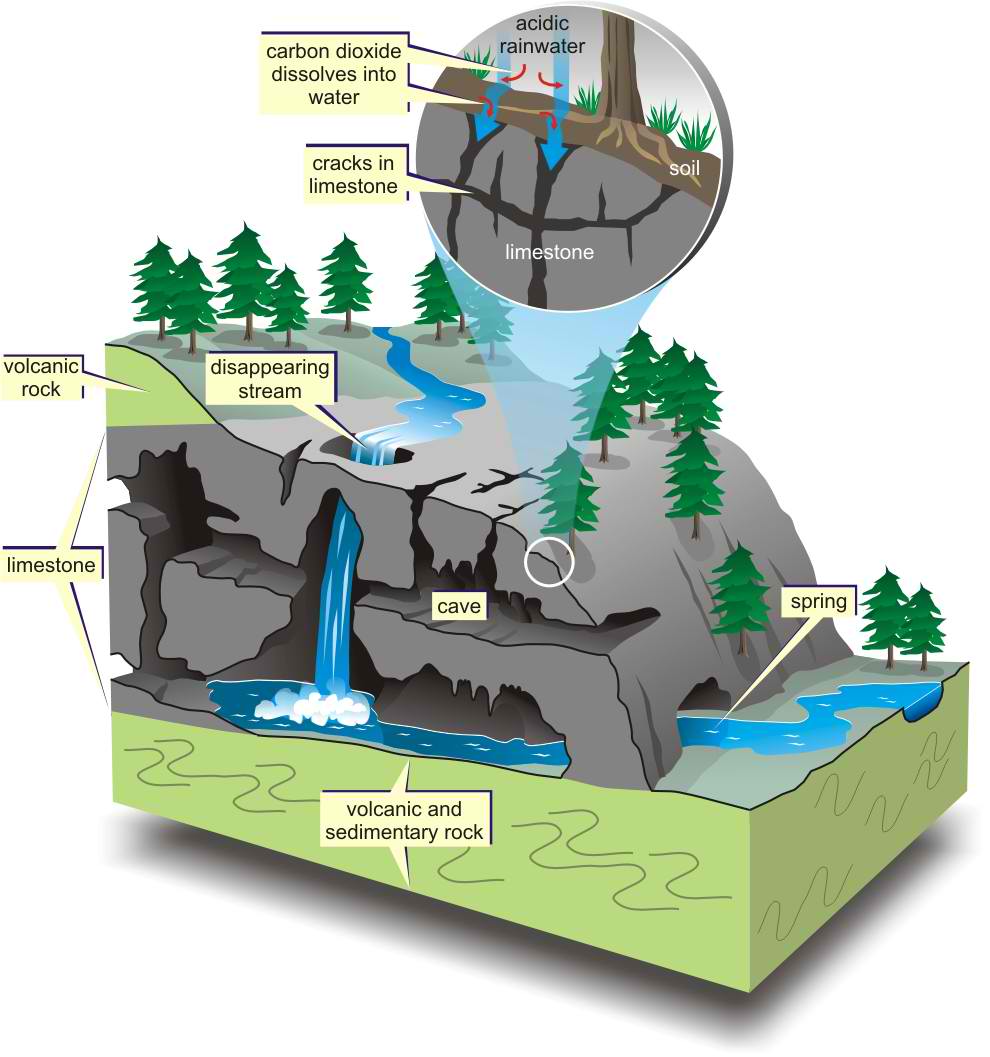
The water becomes weakly acidic because it reacts chemically with carbon dioxide that occurs naturally in the atmosphere and the soil. This acid is named carbonic acid and is the same compound that makes carbonated beverages taste tangy. Rainwater seeps downward through the soil and through fractures in the rock responding to the force of gravity. The carbonic acid in the moving ground water dissolves the bedrock along the surfaces of joints, fractures and bedding planes, eventually forming cave passages and caverns.

Limestone is a sedimentary rock consisting primarily of calcium carbonate in the form of the mineral calcite. Rainwater dissolves the limestone by the following reaction: Calcite + Carbonic acid = Calcium ions dissolved in ground water + Bicarbonate ions dissolved in ground water. Cracks and joints that interconnect in the soil and bedrock allow the water to reach a zone below the surface of the land where all the fractures and void spaces are completely filled (also known as saturated) with water. This water-rich zone is called the saturated zone and its upper surface is called the water table. The volume of void space (space filled with air or water) in soil or bedrock is termed porosity. The larger the proportion of voids in a given volume of soil or rock the greater the porosity. When these voids are interconnected, water or air (or other fluids) can migrate from void to void. Thus the soil or bedrock is said to be permeable because fluids (air and water) can easily move through them. Permeable bedrock makes a good aquifer, a rock layer that holds and conducts water. If the ground water that flows through the underlying permeable bedrock is acidic and the bedrock is soluble, a distinctive type of topography, karst topography, can be created.

The first part of our animation shows evolution of karst landforms created by downward movement of water accompanied by dissolution of rock and mass transport of sediments in stream channels. In tropical areas with thick massive limestones, a remarkable and distinctive landscape of jagged hills and narrow gorges completely dominates the landscape. Movement of solution along fractures and joints etches the bedrock and leaves limestone blocks as isolated spires or pinnacles. Pinnacles range from small features a few inches tall to intermediate forms a few feet tall to large pinnacles hundreds of feet tall. Besides the etching of pinnacles and residual hills, sheets of flowing water move down sloping surfaces creating a variety of etched surface features. Our computer animation shows the dominant landforms, such as pinnacles, cones, and towers, commonly found in the tropical karst environment of northern Puerto Rico.

Our paper model represents another type of karst landscape, that of a rolling limestone plain such as is found in south-central Kentucky, northern Florida, and the Highland Rim of central Tennessee where doline karst is the dominate feature. Doline karst is the most widely distributed type of karst landscape. The landscape is dotted with sinkholes (dolines) which can vary widely in number and size. For the Sinkhole Plain in central Kentucky, there are approximately 5.4 sinkholes per square kilometer over a 153 square kilometer area. For north Florida there are almost 8 sinkholes per square kilometer over a 427 square kilometer area (White, 1988, table 4.1, page 100). Karst topography dominated by sinkholes or dolines usually has several distinct surface features. Our paper model shows features normally associated with karst topography.

Sinkholes (also known as dolines) are surface depressions formed by either: 1) the dissolution of bedrock forming a bowlshaped depression, or 2) the collapse of shallow caves that were formed by dissolution of the bedrock. These sinkholes or shallow basins may fill with water forming lakes or ponds. Springs are locations where ground water emerges at the surface of the earth. Disappearing streams are streams which terminate abruptly by flowing or seeping into the ground. Disappearing streams are evidence of disrupted surface drainage and thus indicate the presence of an underground drainage system. Cave entrances are natural openings in the earth large enough to allow a person to enter. Caves may reflect a complex underground drainage system.

Baca Selengkapnya ....

Bowen's Reaction Series

Posted by Blogger Koetai 0 comments
Bowen found by experiment that the order in which minerals crystallize from a basaltic magma depends on temperature. As a basaltic magma is cooled Olivine and Ca-rich plagioclase crystallize first. Upon further cooling, Olivine reacts with the liquid to produce pyroxene and Ca-rich plagioclase react with the liquid to produce less Ca-rich plagioclase. But, if the olivine and Ca-rich plagioclase are removed from the liquid by crystal fractionation, then the remaining liquid will be more SiO2 rich. If the process continues, an original basaltic magma can change to first an andesite magma then a rhyolite magma with falling temperature.

Baca Selengkapnya ....

Types of Volcanic Eruptions

Posted by Blogger Koetai 0 comments
Volcanic eruptions, especially explosive ones, are very dynamic phenomena. That is the behavior of the eruption is continually changing throughout the course of the eruption. This makes it very difficult to classify volcanic eruptions. Nevertheless they can be classified according to the principal types of behavior that they exhibit. An important point to remember, however, is that during a given eruption the type of eruption may change between several different types.
  • Hawaiian - These are eruptions of low viscosity basaltic magma. Gas discharge produces a fire fountain that shoots incandescent lava up to 1 km above the vent. The lava, still molten when it returns to the surface flows away down slope as a lava flow. Hawaiian Eruptions are considered non-explosive eruptions. Very little pyroclastic material is produced.
  • Strombolian - These eruptions are characterized by distinct blasts of basaltic to andesitic magma from the vent. These blasts produce incandescent bombs that fall near the vent, eventually building a small cone of tephra. Sometimes lava flows erupt from vents low on the flanks of the small cones. Strombolian eruptions are considered mildly explosive, and produce low elevation eruption columns and tephra fall deposits.
  • Vulcanian - These eruptions are characterized by sustained explosions of solidified or highly viscous andesite or rhyolite magma from a the vent. Eruption columns can reach several km above the vent, and often collapse to produce pyroclastic flows. Widespread tephra falls are common. Vulcanian eruptions are considered very explosive.
  • Pelean - These eruptions result from the collapse of an andesitic or rhyolitic lava dome, with or without a directed blast, to produce glowing avalanches or nuée ardentes, as a type of pyroclastic flow known as a block-and-ash flow. Pelean eruptions are considered violently explosive.
  • Plinian - These eruptions result from a sustained ejection of andesitic to rhyolitic magma into eruption columns that may extend up to 45 km above the vent. Eruption columns produce wide-spread fall deposits with thickness decreasing away from the vent, and exhibit eruption column collapse to produce pyroclastic flows. Plinian ash clouds can circle the Earth in a matter of days. Plinian eruptions are considered violently explosive.
  • Phreatomagmatic - These eruptions are produced when magma comes in contact with shallow groundwater causing the groundwater to flash to steam and be ejected along with pre-existing fragments of the rock and tephra from the magma. Because the water expands so rapidly, these eruptions are violently explosive although the distribution of pyroclasts around the vent is much less than in a Plinian eruption.
  • Phreatic (also called steam blast eruptions) - result when magma encounters shallow groundwater, flashing the groundwater to steam, which is explosively ejected along with pre-exiting fragments of rock. No new magma reaches the surface.

Baca Selengkapnya ....

Volcanic Eruptions

Posted by Blogger Koetai 0 comments
Volcanic Eruptions
  • In general, magmas that are generated deep within the Earth begin to rise because they are less dense than the surrounding solid rocks.
  • As they rise they may encounter a depth or pressure where the dissolved gas no longer can be held in solution in the magma, and the gas begins to form a separate phase (i.e. it makes bubbles just like in a bottle of carbonated beverage when the pressure is reduced).
  • When a gas bubble forms, it will also continue to grow in size as pressure is reduced and more of the gas comes out of solution. In other words, the gas bubbles begin to expand.
  • If the liquid part of the magma has a low viscosity, then the gas can expand relatively easily. When the magma reaches the Earth's surface, the gas bubble will simply burst, the gas will easily expand to atmospheric pressure, and a non-explosive eruption will occur, usually as a lava flow (Lava is the name we give to a magma when it on the surface of the Earth).
  • If the liquid part of the magma has a high viscosity, then the gas will not be able to expand very easily, and thus, pressure will build up inside of the gas bubble(s). When this magma reaches the surface, the gas bubbles will have a high pressure inside, which will cause them to burst explosively on reaching atmospheric pressure. This will cause an explosive volcanic eruption.
Nonexplosive Eruptions
Non explosive eruptions are favored by low gas content and low viscosity magmas (basaltic to andesitic magmas).
  • If the viscosity is low, nonexplosive eruptions usually begin with fire fountains due to release of dissolved gases.
  • Lava flows are produced on the surface, and these run like liquids down slope, along the lowest areas they can find.
  • Lava flows produced by eruptions under water are called pillow lavas.
  • If the viscosity is high, but the gas content is low, then the lava will pile up over the vent to produce a lava dome or volcanic dome.
Explosive EruptionsExplosive eruptions are favored by high gas content and high viscosity (andesitic to rhyolitic magmas).
  • Explosive bursting of bubbles will fragment the magma into clots of liquid that will cool as they fall through the air. These solid particles become pyroclasts (meaning - hot fragments) and tephra or volcanic ash, which refer to sand- sized or smaller fragments.
  • Blocks are angular fragments that were solid when ejected.
  • Bombs have an aerodynamic shape indicating they were liquid when ejected.
  • Bombs and lapilli that consist mostly of gas bubbles (vesicles) result in a low density highly vesicular rock fragment called pumice.
  • Clouds of gas and tephra that rise above a volcano produce an eruption column that can rise up to 45 km into the atmosphere. Eventually the tephra in the eruption column will be picked up by the wind, carried for some distance, and then fall back to the surface as a tephra fall or ash fall.
  • If the eruption column collapses a pyroclastic flow will occur, wherein gas and tephra rush down the flanks of the volcano at high speed. This is the most dangerous type of volcanic eruption. The deposits that are produced are called ignimbrites if they contain pumice or pyroclastic flow deposits if they contain non-vesicular blocks.
  • If the gas pressure inside the magma is directed outward instead of upward, a lateral blast can occur. When this occurs on the flanks of a lava dome, a pyroclastic flows called a glowing avalanche or nuée ardentes (in French) can also result. Directed blasts often result from sudden exposure of the magma by a landslide or collapse of a lava dome.

Baca Selengkapnya ....